Fire danger still looms

Ways offered to deal with smokey air


Last updated 9/7/2022 at 11:31am

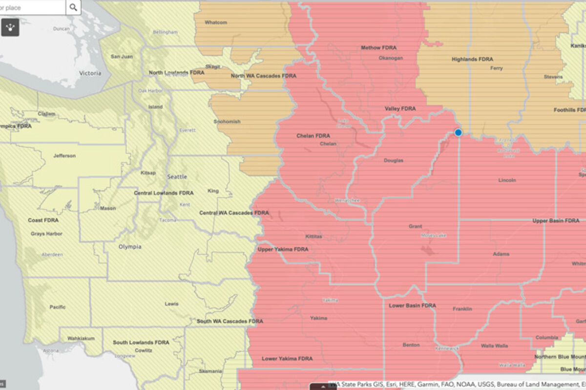
A map showing current fire danger in the state. Most local areas are listed as "extreme" or "very high."

Fall approaching doesn't mean we are in the clear as far as wildfires go, and many of our worst fire seasons have happened in September and October.

"Washington state is in the midst of wildfire season," the Washington State Department of Health warned in a statement last week. "Although it's been a mild season to date, it is important to be prepared and ready to protect yourself and your family from wildfire smoke before the smoke hits."

It was in September of 2020 that about half a million acres were burning in areas not far from the Coulee, including the Cold Springs Fire, which burned 189,000 acres near Omak, jumped the Columbia River and started the Pearl Hill Fire, which burned about 234,000 acres near Bridgeport and Mansfield; the Inchelium Complex of fires that burned 19,000 acres on the Colville Reservation; and the Whitney Fire, which burned 127,000 acres near Davenport and Creston.

"Red flag" warnings from the National Weather Service have been common recently in many parts of Washington, including the Coulee area, due to low humidity and windy conditions that make the spread of current fires or starts of new fires more likely.

Although comparatively small in size, the Aug. 11 lightning-caused White River Fire in Chelan County, currently at 4,500 acres and only 1% contained, has sent smoke to the Coulee area at times when the wind blew it east.

And a Lincoln County fire at Seven Bays has burned 1,000 acres and was causing the need for evacuations in that area as of Tuesday afternoon.

"When it does get smoky outside, the best way to protect everyone, including pets, is to stay inside and keep indoor air as clean as possible," DOH said. "Exposure to smoke from fires can cause several health problems that range from minor to severe. The worst symptoms often occur in people with pre-existing health conditions, but smoke is unhealthy for everyone. Symptoms include burning eyes, coughing, throat and nose irritation, headaches, fatigue, wheezing and shortness of breath, irregular heartbeat, and chest pain."

Legend for fire danger map

DOH suggests buying " a HEPA portable air cleaner, which will filter out smoke and help create a cleaner air room you can spend time in when it's smokey outside. You can also make a DIY box fan filter as a lower-cost option. It's key to plan ahead and buy supplies in advance because they often sell out quickly when it's smoky out."

An online air quality map is available at PurpleAir.com, and shows the air quality of a given area, and surrounding areas, based on local sensors.

That site can be found at https://map.purpleair.com/

Current information on wildfires can be found using an interactive map from the National Wildfire Coordinating Group website at https://inciweb.nwcg.gov/ in which a user can click on a given fire to learn the acreage, containment level, and more.


Reader Comments(0)


Powered by ROAR Online Publication Software from Lions Light Corporation
© Copyright 2024

Rendered 04/08/2024 15:46