
News, views and advertising of the Grand Coulee Dam Area
News, views and advertising of the Grand Coulee Dam Area
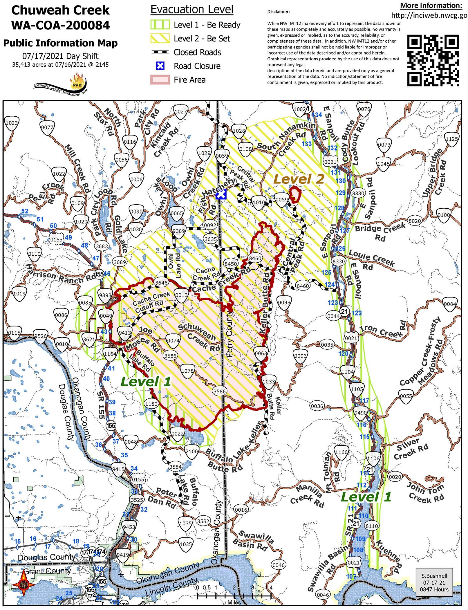
Click on map to enlarge
A map of some of the lightning strikes that hit the area Monday night. The image is a screenshot of the Weatherbug apps lightning feature. The National Weather Service told tribal fire officials there were about 60 strikes.
Here is this morning's update on the Chuweah Creek Fire from the incident commander, along with an updated map. Cooler weather is helping for now, and acreage estimates have been changed with better mapping.
CHUWEAH CREEK FIRE UPDATE
NORTHWEST INCIDENT MANAGEMENT TEAM 12
Incident Commander: Bobby Shindelar July 17, 2021 8:00 AM
Operations Today:
Firefighters continue to make good progress on the Chuweah Creek Fire,
which was started by lightning on July 12 and is burning east of Nespelem.
Yesterday, lower temperatures and a reduction in wind gave resources a
chance to make progress on securing line around the fire.
Crews will focus on the southeast corner above Cache Creek Rd. to find a
direct route to attack the fire, as well as the northeast corner, working north
along Keller Butte Ridge to halt fire progress. An aggressive approach will
be taken today during both day and night shift in anticipation of an increase
in temperatures and the potential for thunderstorms early next week.
With better mapping, the acreage on Incident 90 (Central Peak Fire) is
estimated to be approximately 213 acres. There is a dozer line around the
fire and firefighters continue to monitor and mop up around the perimeter. It
is burning two miles northeast of the Chuweah Creek Fire.
Level 2 evacuations remain in place along Cache Creek Rd. and in the
area of Owhi Flats and Owhi Lake. Level 1 evacuations remain in place in
Nespelem, Keller and the San Poil Valley south of South Nanamkin Rd.
Evacuations and Road Closures:
• Level 1 evacuation notifications are in place for residents of
the town of Nespelem as well as the town of Keller, Buffalo
Lake and McGinnis Lake communities and the San Poil
Valley/Highway 21 corridor from South Nanamkin to the Keller
Ferry.
• Level 2 evacuations are in place for residents at Owhi Flats
and east of Owhi Lake, as well as residences along Cache
Creek Rd.
Road closures include:
• Cache Creek Road
• Buffalo Lake Road between Manila and Cache Creek Rd.
• Cache Creek (Agency) Cut Off Road
Air quality information is available at http://wasmoke.blogspot.com/
Update 10:45 a.m. 7-16-21
The Chuweah Creek Fire grew another 5,000 acres in the last 24 hours, and firefighters are working to protect structures along Cache Creek Rod and hld te fire along the easter edge of Keller Butte Road, a report from incident command said this morning. It now encompasses 37,283 acres.
"Fire growth has slowed considerably along the northeastern edge between Nespelem and Buffalo Lake," the report noted.
"Level 3 evacuations that were in place along Cache Creek Rd. have been reduced to level 2. Level 1 evacuations remain in place in Nespelem, Keller and the San Poil Valley south of South Nanamkin Rd.," the report continues.
A community meeting will be held at the Keller Community Center today, July 16, at 1:30 PM. That meeting will also be streamed via Facebook on the Northeast Washington Fire Information page.
Evacuations and Road Closures:
• Level 1 evacuations are in place for residents of the town of
Nespelem as well as the town of Keller, Buffalo Lake and
McGinnis Lake communities and the San Poil Valley/Highway 21
corridor from South Nanamkin to the Keller Ferry.
• Level 3 evacuations have been reduced to level 2 for residents at
Owhi Flats and east of Owhi Lake, as well as residences along
Cache Creeks Rd.
Road closures include:
• Cache Creek Road
• Buffalo Lake Road between Manila and Cache Creek Rd.
• Cache Creek (Agency) Cut Off Road
Fire Update 10:45 a.m. 7-15-21
At 8:50 a.m. this morning, fire officials reported the Chuweah Creek fire has grown to 32,290 acres in size, at about 20 percent containment.
The fire grew toward the east and northeast, aided by wind, fuels and terrain, crossing Cache Creek Rd. east of Shiloh Rd.
The fire has burned east to Keller Butte Road and has crossed the road in several places.
"The fire is expected to grow as high temperatures, low relative humidity and gusty winds are predicted across the area today," the update says. "Additional resources have been ordered and will be assigned to the fire as regional priorities allow. Air resources will be heavily utilized again today."
Fire Update 12:45 a.m. 7-15-21
At 8:25 p.m. last night, fire officials reported the Chuweah Creek fire is burning south and east of Nespelem and has grown to 22,900 acres, about 20 percent contained.
They're estimating containment at midnight July 23.
Incident Commander Robert Shindelar, of NW Team 12, assumed command at 6 a.m. Wednesday. He reports that 200 personnel are on the fire, which is predicted to move east and north toward Cache Creek Road.
Because of the hot, dry weather and many other fires in the region, ground resources are hard to come by, but "an aggressive air attack strategy is underway with additional aircraft on order," Wednesday night's report reads. "Please avoid waterways and air space in the fire
area to allow planes and helicopters to work safely.
No drones should be operated anywhere near fire air space, officials caution. That halts efforts to fight fire from the air.
"The fire is expected to grow as high temperatures, low relative humidity and gusty winds are predicted to continue across the area through Thursday," the report continues.
"With the current weather there are simply not enough resources to protect residences and other structures and contain the amount of fire perimeter. Additional engines and crews are needed along with line supervisors to manage them. Additional heavy equipment is needed as well," reads a fire report on InciWeb incident information system site.
Some weather relief is expected through Saturday, however, with high temperatures cooling to the 80s. But relative humidity will remain very low and winds elevated through the weekend. Humidity was in the single digits Wednesday, making it easier for fuels to burn.
Evacuations and Road Closures:
Level 1 evacuations are in place for residents of the town of Nespelem.
Level 2 evacuations are in place for residents at Owhi Flats along Cache Creek Rd.
Level 2 evacuations are in place for residents in Buffalo Lake and McGinnis Lake communities.
Road closures include:
• Cache Creek Road
• Buffalo Lake Road between Manila and Cache Creek Rd.
• Cache Creek (Agency) Cut Off Road
• Joe Moses Road
Earlier story:
Five fires sparked by lightening Monday night have consumed more than 10,000 acres on the Colville Reservation, forcing evacuations around Nespelem, killing livestock, and burning seven homes so far, three of which had been occupied.
The Chuweah Creek/Joe Moses fires near Nespelem have burned about 10,000 acres, a Mt. Tolman Fire Center release this afternoon said. It is 0% contained and burning in tall grass, sage brush and timber, driven by wind.
Level 3 evacuations are still in place for residents at Owhi Flats along Cache Creek Road, the town of Nespelem and the Colville Indian Agency.
An evacuation center has been set up at the Lake Roosevelt High School gymnasium in Coulee Dam. Colville Tribal Convalescent Center residents have been evacuated to the Coulee House Motel in Coulee Dam.
The fire took out CenturyLink equipment, leaving the town, the agency, Tribal Police, and the Mt. Tolman Fire Center, itself, without phone service.
The release said that several livestock, horses, and wildlife had been killed by the fire or were severely injured and had to be put down.
The fire started about 7:15 Monday night when a thunderstorm rolled over the land, lightning striking the earth about 60 times.
A reconnaissance flight took place early Tuesday to search for new fires and determine the storm's path, the release said. Answers will inform an air attack on fires that exist now and those that could still appear.
So far, Mt. Tolman's own crews, along with firefighters from every local department, have been been fighting the fires, and state Dept. of Natural Resources firefighters got "boots on the ground" Tuesday morning release said. A Type 2 Incident Management Team is expected to arrive by 8 p.m. for a briefing with local agencies at the Keller Community Center, where an incident command post has been established.
The tribal government decided Tuesday to close the reservation in "a state of emergency ... due to multiple uncontrolled fires," a tribal statement issued in the evening said. "The Reservation is currently shut down to industrial activities and to the general public. The Tribes has imposed an Industrial Fire Precaution Level IV general shutdown, which closes all forest roads to the public. State and county improved roads (with a paved or gravel surface) remain open."
"Our priority is always the safety of all people on the Colville Reservation, and we will also protect property to the best of our ability," Colville Business Council Chairman Andy Joseph, Jr. stated. "Our hearts and thoughts go out to the people already impacted by these fires. We thank those coming onto our land to assist us in fighting these fires, and we appreciate the donations and offers for help that are already coming in. The need for action to protect our climate, and to mitigate the effects of climate change, becomes clearer with each passing year and each round of devastating fires."
Resources on the fire include three dozers, a Type-2 hand crew, 11 Type-6 fire engines, and two water tenders.
A Facebook post by Grand Coulee Dam area firefighters at about 1 a.m. Tuesday said local departments were all helping and standing by with more resources if needed.
In addition to the fires near Nespelem, the Keno Fire northeast of Keller is "completely lined" at 25-30 acres.
In the Inchelium District, the Wells/Gold Mountain Fire (renamed from Frosty Meadows/Friedlander Fire) has burned half and acre and is within containment lines with one Type-6 fire engine on it.
The Summit Trail Fire is 10-15 acres and burning toward a previous burn scar where the Bridge Creek Fire took place within September 2020's Inchelium Complex that burned 18,940 acres.
Current road closures include Buffalo Lake Road at the Colville Indian Agency to the Buffalo Lake Access Road. SR-155 is open.
The National Weather Service in Spokane has issued a red flag warning for wind and low humidity until 11 p.m. Thursday, with winds expected out of the southwest from 10 to 15 mph and gusts up to 25. Relative humidity is expected between 7 and 14 percent Thursday, making it easier for fuels to catch fire.
How to donate for recovery
The Colville Tribes said Tuesday they'd been approached by concerned parties wanting to donate toward recovery efforts following the fires.
Those wanting to donate items should contact Brian Nanamkin at (509) 978-9197, who can coordinate such donations and "discuss the types of donations that are helpful at this time," the tribes said in a statement.
"Financial donations are the fastest, most effective and flexible way to donate to assist fire response," the statement continued.
"The Tribes' Chief Financial Officer, William Nicholson II, is ready to accept and account for any monetary donations made to the Tribes to defray expenses due to the current fires. He may be reached at (509) 634-2857 or at billy.nicholson.act@colvilletribes.com," the Tribes stated.

Reader Comments(0)