
News, views and advertising of the Grand Coulee Dam Area
News, views and advertising of the Grand Coulee Dam Area
Sorted by date Results 126 - 150 of 157

My goodness, August really brought the rain. SO, how much rain you ask? What we received exceeded all of the past six years for August. Our combined past six years for August brought a total of 1.29 inches. Now, let’s compare the totals for August 2014 – my home weather station received 1.55 inches, and the Grand Coulee Dam weather site got 1.76 inches. The mean for August is 0.41 inches, with an all-time 1.75 inches in 1941. Do you see a new record? I certainly did, and the National Wea...
Hot indeed, July was, to quote Yoda. I’ve been looking over the records for the month of July at the “official weather station” here in the Grand Coulee area (Coulee Dam 1 SW [451767]). As expected, there are fluctuations from year to year. Some examples: From 1935-41 July had maximum temperatures over the 100°F mark. The next such run of years for July was 1944-47 and then 1958-62 and so on. Well, you get the picture; it varies. The most recent grouping of years for July with maximum temper...
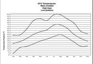
Reviewing the past five June’s, June 2014 comes in as the driest. Here at the home weather station we only measured 0.59 inches, while the mean for June is 1.04 inches. Here’s how that ranks going back to 2009: 2013- 1.51 inches, 2012- 3.35 inches, 2011- 0.60 inches, 2010- 2.33 inches, and 2009- 0.93 inches. Temperatures were comparable, though, to these past years. We had a high of 88.1°F (June 23) and a low of 43.7°F (June 16). Only once in the past five years did we break into a high tempe...
The mean precipitation for May is 1.10 inches, and this year, like 2013 and 2012, we only received a portion of that. We measured 0.63 inches here at the home weather station (compared to the same in 2013 and just 0.27 inches in 2012). The mean temperature was 60.0°F was 1.6°F higher than mean (all-time mean is 58.4°F). The high for the month was 84.7°F and the low was 38.0°F. The all-time high was 100°F back in 1986, and the all-time low was 21°F in 2002. There has been discussion about El Nino...
I had hoped for warmer weather for Colorama and Mother’s Day weekend; we take what we get, as someone once said. If you recall, last year was very warm with temperatures in the high 80s, low 90s and clear sky. Here are the numbers for April. Our high temperature here at the home weather station was 74.0°F on the last day of the month (all-time high 92.0°F in 1936), a low of 30.7°F (all-time low 20.0°F in 1936) and the mean was 50.3°F (all time mean 50.0°F). Turned out the month was rather...
We ushered in a seasonal change on March 21 with equal day and night times. Now, we are gaining more and more daylight as we head into summer. We are gaining roughly three minutes a day. For the month of April, we will gain an hour and 16 minutes of daylight. Let’s take a look at March and see where the numbers ended. Precipitation was nearly a half inch more than the mean at 1.28 inches, while the mean is 0.88 inches. The record high, set in 2012, was 4.13 inches. We measured 1.4 inches of n...
February left us with a good amount of snow and was our coldest month, too. We measured 8.3 inches of new snow here at the home weather station (compared to a mean snowfall is 2.5 inches and a high of 17.1 inches in 1959) and a low temperature of minus 1.8°F on the 6th of the month (minus 15°F was our lowest in 1950). Our total precipitation was 1.46 inches which, as always this time of year, includes Snow Water Equivalent (SWE). The high temperature for the month was 51.6°F on the 12th (61°F wa...
January kicked off our new year on the warmer and drier side. Here at the home weather station we had a January mean temperature of 31.5°F, while the overall mean is 26.9°F for a difference of 4.6°F. The low for the month was 14.9°F on Jan. 31 (all-time low was -17°F in 1950) and our high was 55.9°F Jan. 13 (all-time high was 61°F in 1981). Our January precipitation was on the low side. We measured only 0.49 inches, just about all of it from 4.9 inches of snowfall (actually, it is called Snow Water Equivalent or SWE). Our mean precip...
For December, here at the home weather station, we only had three days of low temperatures in the single digit area — the 5th, 7th and 8th. The lowest was a 3.5°F on the 8th, while our high temperature came in at 42.8°F on the 1st. Record temperatures for December are an all-time low of minus 16°F in 1968 and the all-time high of 58°F back in 1936. The mean for the month is 29.5°F and this December ours was 26°F, 3.5°F lower. Again, we were on the dry side of precipitation. Only 0.15 inches a...
The joy of working with computer recording software unsurprisingly leads to a bit of frustration. Here at the home weather station we have a gap of eight days lost – the last eight days of November. For November reporting purposes, I’ll be using data from another local recorded weather station. Temperature ranges were as follows: the low for the month was 14°F (Nov. 21) and the high was 56 (Nov. 1). The all-time low for November was -10°F in 1985, while the all-time high was 69°F in 1989....
The home weather station measured a trifling 0.14 inches of precipitation for October. Looking back at past years shows we’ve had more — 1.15 inches in 2012, 0.54 inches in 2011, 1.23 inches in 2010 and 1.36 inches in 2009. The mean for October is 0.72 inches. We’ve been above the mean three of the last five years. Temperatures were generally on par with a high of 70.7°F occurring on the 6th of the month and a low of 29.1°F on Oct. 30. The all-time mean for October is 51.1°F; all-time high was...
The high temperatures we had up to mid-September, 80s and 90s, have dropped off measurably. As we transitioned into October we’ve had nothing above the high 70s. I think it’s fair to state we are now in autumn weather. My home weather station recorded a high temperature of 95.9°F on Sept. 13 (all-time high was 104°F in 1938) and a low of 39.5° on the September 25 (all-time low of 30°F in 1970). Precipitation was on the light side though above the mean (0.72 inches) with 0.88 inches recorde...
Aug. 25 saw a very strong, fast moving storm system blow through our area. We continue to clean up the mess left behind. Winds of 65 miles per hour and above were noted in many areas. Here at the home weather station, where we are a bit protected, we had a gust of 43 mph and a third of an inch of rain from the system. As I write this column, we just experienced another fast moving storm system. Fortunately, it appears this one wasn’t as strong or severe as the Aug. 25 event. Our temperature rang...
Sadly, this morning, I found yet another causality of the high tension power lines that cross over North Dam Park. Since I’ve been walking the area, about eight or nine months, I’ve witnessed three bird fatalities. The first was a dead Canada goose, second was a dead gull species and today, a night hawk. Though still alive and breathing heavily, it was obviously in bad shape. I moved it into the grass and off the gravel road. My observations are, at best, casual. Interestingly, all the bir...
I’m still wiping my brow of perspiration from all that heat. The National Weather Service reported some near- and new-high temperature records throughout the region. Here at the home weather station we had a new record of 102.3°F on July 2. We recorded a total of 18 days at or above the 90°F mark. We didn’t come close to the all-time high of 113°F that occurred in 1939. Our low for the month was on the 13th at 52.9°f. Precipitation was a measly 0.29 inches, well below the mean of 0.48 inches....
June was wetter than the month’s mean. We measured 1.32 inches of precipitation at the home weather station compared to a mean of 0.99 inches. Our high temperature was 92.9°F and occurred on the last day, while the coldest day of June was on June 1 at 44.8°F. Records for June are: highest rainfall - 4.29 inches in 1937; lowest rainfall - 0.04 inches in 2003; one day maximum - 2.31 inches in 1996. I was recently asked by a reader of this column to define the difference between the words “average...
A dry April into a dry May I’ve been checking into the National Weather Service’s Climate Prediction Center’s three-month prediction (June, July and August), and it states, “…an equal chance of above or below normal temperatures and below normal precipitation.” April 2013 wasn’t a wet one with only 0.91 inches of precipitation. We seem to be on course, here’s a review of some past Aprils (2012 – 1.08 inches, 2011 - .84 inches, and 2010 – 1.12 inches). The high temperature in April was 78.5°F wh...
The mean precipitation for March was 0.82 inches, though here at the home weather station we only received 0.36 inch, a huge variance from last year’s March total of 2.64 inches. What a difference a year makes, hey. Temperature-wise, this March we had a mean of 42.5°F (41.1°F mean) with a monthly low of 22.2°F (record low 0.0°F) accompanied by a monthly high of 71.6°F (record 74.0°F). So, we were off by a half inch in precipitation and generally near averages for temperatures. As I write t...
Dry indeed, February brought a parching 0.09 inch of precipitation that included 0.6 inch of fresh snow. The mean precipitation is 0.92 inch while we had a high of 3.58 inches back in 1940. Mean snowfall is 2.5 inches. So, as you can see, we were behind by about 90 percent. Temperatures were higher, as well. The mean for February here at the home weather station was 34.2°F, while the historical mean is 32.7°F. That’s a 1.5°F uptick from the mean. The low for the month was 24.1°F (average minim...
Reviewing data from the past four Januarys shows we didn’t have any changes from the normal. We had good, measurable snowfall this year (2013, 7.3 inches) and last (2012, 9.9 inches). Here’s how it broke down for 2013 and showing all-time records in parenthesis. High temperature 46.0°F(record is 61°F), low 12.7°F (record -17°F), mean 26.5°F (record 36.1°F), total precipitation 0.60 inches (2.25 inches) and snowfall 7.3 inches (21.6 inches). January was nothing to write home about. Given the...
Reviewing data sets for December 2011 and 2012 shows we were a bit warmer and wetter. Our low for December 2012 was 21.9°F compared to 2011, which was 16.4°F. That’s a 5.5 degree difference. The all-time low temperature for December was a minus 16°F in 1968, while the mean low is 29.6°F. Precipitation shows a difference of 1.63 inches. We measured 2.12 inches for 2012, while in 2011 we received only 0.49 inches. Snow accumulation for December 2012 was 6.4 inches and in 2011 just 1.3 inches. For...
Our snowfall certainly wasn’t anything to get too thrilled about. Over a two-day period, the Dec. 10-11, we got 1.9 inches of snowfall here at the home weather station. That’s slightly more than the November mean of 1.4 inches. Mean precipitation for November is 1.25 inches, while we recorded a meager half inch here at home. For the year, we are well above our average precipitation of 10.50 inches, currently at 13.56 inches here at home. We had a November mean temperature at 40.9°F, below the...
If the presence of snow indicates winter’s arrival along with less daylight, I’d say winter is here. So far, here at the home weather station, we’ve had 1.9 inches of snow with rapid melt-off. We’ve had three days of low temperatures below the freeze level, too. The coldest being 21.6°F. More of those to come, I’m sure. Here’s a tip of the hat to winter. November can be cold and the records show that in 1985 we had a -10°F. Our mean temperature is 37.5°F. Mean precipitation is 1.25 inches an...
The start of October has been really pleasant fall weather. It really is a nice treat. Our first recorded low back in the 30°F range occurred on Oct. 4. The last 30°F range low was way back on May 12. We are still dry -- way too dry, frankly -- and we are all reminded of that fact with the recent wildfires that have occurred around our region. Excluding the 0.01 inch of rain on Sept. 8 here at the home weather station, we haven’t seen any rain since July 20 -- that’s 80 days as of this writi...

We were visited by quite a nice line of thunderstorms on July 20. I watched these storms approach from the south that afternoon on the Spokane National Weather Service radar on their website. The storms were impressive as were the speeds they travelled. Here at the home weather station we ended up with a half inch of rain and a 40 mph wind gust in just over an hour. Extensive damage occurred here in our communities and many of you heard that North Central Washington was hit hard by those...