
Planners think about wildfire in Ok. County
Last updated 4/3/2024 at 1:55pm
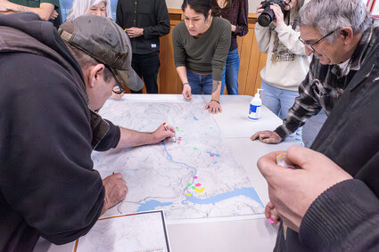
Ed Hartbarger, left, uses a red marker to indicate a major powerline that supplies Nespelem Valley Electric as people decide where to place the three dots they were given to indicate priorities during a wildfire. - Scott Hunter photos
Big maps up on a screen made an impression.
The maps outlined all the areas burned by wildfires in Okanogan County. The first slide showed burns from 1982 through 2013. The second slide added what has burned since 2013. From a glance at the map, you might guess that possibly twice as much land burned in the last 11 years as in the prior 31.
In a room full of firefighters and others concerned with keeping the county from burning up, it was an appropriate intro to the Community Wildfire Protection Plan (CWPP) discussion for Okanogan County.
A couple dozen or so people attended the meeting at the government center of the Colville Tribes March 27, the third of five meetings around the county led by the Okanogan Conservation District.
Eli Loftis, the district's wildfire program lead, said the plan is intended to encourage collaboration between entities and agencies that need to coordinate efforts before wildfire hits an area, and should be renewed every five to 10 years. The last one was done 11 years ago.
This could be the year it's needed. With La Niña weather patterns expected to affect precipitation in the state, wildfire officials are bracing for it. Okanogan County Sheriff Paul Budrow told county commissioners last week they are preparing for a serious fire season.
At the Colville Tribes' headquarters Thursday, people gathered around large, detailed maps of each area of the county, supplied with three colored sticky dots to place on areas they thought should be given priority in a fire situation.
Ed Hartbarger, a Nespelem Valley Electric employee and a volunteer with the Coulee Dam's fire department, drew a red line on the map to emphasize the utility's tie to the main powerline feeding NVE. Dots went on communications towers too. Some noted cultural resources. All marked community "values," priorities that suggest what to save if you have to make a choice.

A map showing how much of Okanogan County burned from 1982 to 2013, and since then through 2023.
Loftis said later it was a "wonderful meeting," with ideas expressed about ways to support elders during a fire, educating youth about fire, and maybe tapping them as another volunteer labor source for brush clearing, and more.
The discussion shared commonalities with others around the county so far: concerns about keeping access to roads open and comments on keeping communications open so people know what's happening.
The meeting is one leg of the process, along with a survey and other comments. A draft plan will be drawn up.
"Think of it as ... drafting a wildfire bible for Okanogan County," Loftis said.
The Okanogan Conservation District's website is at OkanoganCD.org.
The effort is funded by a grant through the state Conservation Commission from the Climate Commitment Act.
A map showing how much of Okanogan County burned from 1982 to 2013, and since then through 2023.
Reader Comments(0)