

By Bob Valen
April brings record snow melt
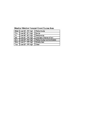
Weather Watcher
Last updated 5/11/2016 at 11:09am
The big weather story, from my perspective, was the record-breaking snowmelt here in the Pacific Northwest. During April, western snowpack dropped at record speed, according to data from the fifth and final 2016 forecast by the U.S. Department of Agriculture's Natural Resources Conservation Service (NRCS).
"In the Pacific Northwest, low precipitation and high temperatures led to a dramatic reduction in snowpack," reported NRCS. "Peak stream flow is arriving weeks earlier than normal this year."
What occurred were two separate ridges of high pressure. The first one came through on April 6, with high temperatures on April 7 and 8. The second one arrived on the 16. We had warm temperatures again from April 17 through April 20. In fact, the high temperature for April, here at the home weather station, was on April 20. As of May 2, the SWE, or Snow Water Equivalent, was only 57 percent of normal in the Upper Columbia region.
El Niño is still lingering, though; the mid-Tropical Pacific sea temperatures are now dropping. In fact, a La Niña Watch has been issued. This means that a transition from El Niño to La Niña will likely occur in early summer. You may ask, "Why the big deal with these niños and niñas?" The deal is these opposites that form in the waters of the Tropical Pacific Ocean affect global weather conditions, including our weather here in the Inland Northwest.
Let's look at the numbers for April. Here at the home weather station we had a high of 84.7˚F (April 20) while the low was 35.0˚F (April 14). The mean was 56.0˚F, some 6˚F higher than the all-time mean of 50.0˚F. The all-time high temperature for April was in 1936 at 92˚F, and the all time low was 20˚F, again in 1936.
This April was a tad drier than normal. I measured 0.75 inches of precipitation for the month. The all-time mean is 0.83 inches, while we had a record of 2.19 inches in 1993. The all-time one-day maximum was in 2011, with 1.10 inches.
For those of us who like to observe night sky space phenomena, we were treated to a really special event the night of Saturday, May 7. According to SpaceWeather.com, this is what happened and what we saw: "In the United States, auroras were sighted due to Earth entering a region of space filled with negative-polarity magnetic fields. Such fields easily link to Earth's magnetic field, opening a crack in our planet's magnetosphere. Solar wind pours in to fuel spectacular auroras. Overall, this was the strongest episode of geomagnetic activity so far in 2016."
For those who need to know, and depending on the condition of lycanthropy, we will experience a full moon on May 21.
Reader Comments(0)