[UPDATE] Fire merger "inconclusive", no structures lost
Community meeting on fire at 4 p.m. today
Last updated 8/24/2015 at 3:27pm
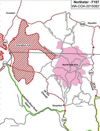
This fire map of transportation routes shows road closures and where the two big fires may have merged yesterday. Some annotation has been added by The Star.
[UPDATE 9:45.a.m 8/22]
Initial reports indicated that the Tunk Block Fire and North Star Fire had merged, however this proved to be inconclusive. When more precise mapping is available, fire managers will able to more accurately determine the perimeters of the fires.
The size of the fire is estmated at 126,522 acres, but it is "very difficult to verify where the fire edge is due to smoke and fire behavior," a management report states.
[Earlier report]
A community meeting on the now 108,000-acre North Star Fire will be held at 4 p.m. today (Saturday) at Lake Roosevelt High School, 503, Civic Way, Coulee Dam, Incident Management Team #5 Incident Commander Rich Nieto has announced.
Information released from the team said the fire had not destroyed any structures as of about 11 p.m. Friday night, even though wind driven flames yesterday enlarged the fire by 20,000 acres and pushed the Tunk Block fire from the west to merge with North Star. The two fires came together just north of Moses Meadow.
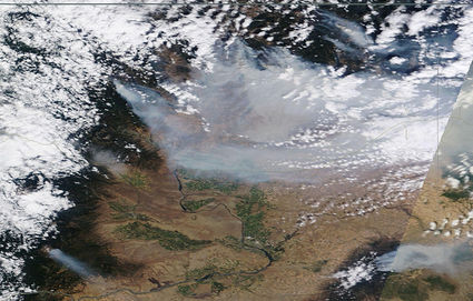
In this satelite image, yesterday's thick smoke looks thickest from the Okanogan Complex and North Star. Lake Chelan is visible.
Firefighters expected that merger, but the fire was not as active as they had feared when planning for yesterday's high winds, Public Information Officer Kathy Moses said last night.
Fire officials say there is "potential for large fire growth and very active fire behavior" today. Crews will build dozer lines north of Nespelem to protect the town and assess road systems, burning out areas where feasible, in a controlled way, to rob the wildfire of fuel.
Persons sensitive to smoke should take precautions and stay inside when possible.
Stage 3 evacuations are still in effect for all of Aeneas Valley.
The area northeast of Nespelem is still under Level 3 evacuations.
Colville Indian Reservation forest and recreational areas are closed to the public due to extreme fire danger.
Highway 21 from Bridge Creek Road north to the reservation boundary is closed. Highway 155 is closed from Nespelem to Omak.


Reader Comments(0)