North Star Fire Tuesday morning report released
Fire now at 150,000 acres
Last updated 8/25/2015 at 10:25am
Click to enlarge.
Here's the latest from the North Star Fire incident command:
NORTH STAR FIRE UPDATE
Tuesday 08/25/2015 –9:00AM
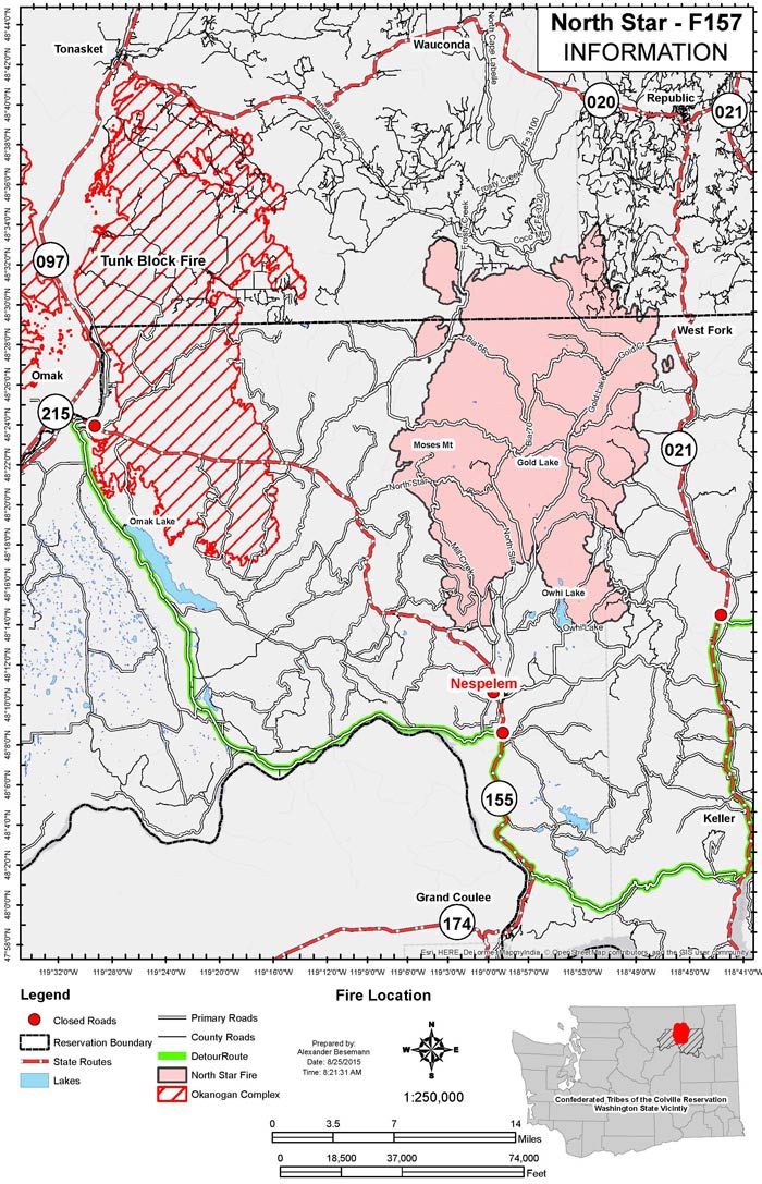
Acres: 150,000 Start Date: August 13, 2015
Cause: Under investigation Location: Approximately 12 miles north of Nespelem, WA.
Containment: 5% Fuels/Topography: Timber, grass and understory
Structures Threatened: 2000 + Total personnel: 539
Community Meeting Tonight, August 25, 2015, 4:00 PM
Republic Elementary School, 30306 East Hwy 20 Republic, WA 99166.
Today's Actions: Red flag conditions will remain in effect until 9PM this evening. Crews will continue constructing direct and indirect lines, providing point protection while also maintaining an anchor point in the southeast section of the fire northeast of Owhi Lake. Scouting continues on the western side of the fire. Structure protection and support for residences continues in all areas. Fire managers will be assessing placement of contingency lines helping with the protection of Republic, along Highway 21 corridor and West Fork. Burnout operations will also be used where feasible to help in the protection of structures in those areas. Smoke is still impacting local communities. Smoke sensitive individuals should take precautionary measures and stay inside when possible. Please visit http://www.airnow.gov/index.cfm?action=airnow.local_state&stateid=49 for more air quality information. Though many structures are still threatened, no structures have been lost in the North Star Fire.
Yesterday's Actions: The fire showed little growth yesterday as it expanded to 150,000 acres. Fire behavior was variable throughout the day, generally backing, flanking and occasional torching within the perimeter. Helicopters provided water drops for crews around Nespelem to strengthen fire perimeter lines. An anchor point has been established on the southeast edge of the fire, near Owhi Flats, using direct line tactics to protect communities to the south. Fire managers assessed road systems and conducted burnout operations where feasible. Crews continued protection of critical communications sites and reinforced firelines to enhance community protection. Structure assessment continued in the surrounding areas.
EVACUATIONS:
Highway 21 from the Colville Indian Reservation boundary north to McMann Creek.
Stage 3 evacuations are still in effect for residents in Moses Mountain Community, Haden Creek, including Owhi Flats, Disautel, along Highway 155, all of Aeneas Valley and West Fork.
CLOSURES:
Okanogan – Wenatchee National Forests closure east of Tonasket and south of highway 20.
Highway 21 from Bridge Creek Road north to the Reservation boundary is closed. Colville Indian Reservation forest and recreational areas are closed to the public due to extreme fire danger.
Volunteer Information: http://www.dnr.wa.gov/WildfireVolunteer
FIRE INFORMATION:
Inciweb: http://inciweb.nwcg.gov/incident/4524/
Facebook: https://www.facebook.com/pages/North-Star-Fire/719347344836918


Reader Comments(0)