Fire burning forest north of Keller
Last updated 7/8/2015 at 9:39am
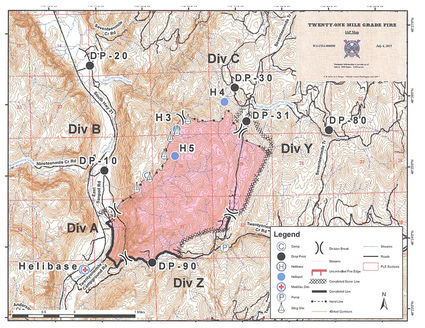
In this map provided by firefighters, the dark area shows the extent of the 21 Mile Grade Fire, which bumps up against the San Poil River and highway 21 at its lower left, with completed dozer lines shown by the lines of Xs. Elevation lines indicate 40-foot changes in elevation and show the steepness of the terrain.
Firefighters have the 21-mile Grade Fire, about 25 miles north of Keller, 40 percent contained, but they will be keeping a watchful eye on reports of thunderstorms predicted this week.
Kathy Moses, public information officer, said the fire has covered 2,250 acres and has been held to the east side of State Route 21.
The cause of the fire is still under investigation, Moses said.
Fire broke out in the afternoon July 1, and quickly spread to 1,000 acres. Fire crews Tuesday were mopping up parts of the northern portion of the fire area.
Moses said over 400 firefighters and five aerial units - one tanker and four helicopters - have been assisting fire crews on the ground.
Tuesday's fire report indicated that the speed of the fire had slowed somewhat and that firefighters continued to make progress even though they were facing hazards of steep terrain, snags weakened by the fire, and falling rock.
Firefighters have been hindered by treacherous terrain and high temperatures, on some days exceeding 100 degrees. Two minor injuries were reported Monday: one firefighter was bitten by a scorpion and a second had a saw injury. Both were treated and returned to the fire line.
Fixed-wing aircraft dropped retardant north and east of the fire late last week and helicopters were working on the hot spots.
Saturday a "red flag" warning was issued because of winds 10-18 mph with gusts to 30 mph. That situation relaxed somewhat Tuesday.
The Tuesday fire report stated that lines from the southwest corner of the fire to the north and east were strengthened and held. On the eastern perimeter a dozer line on an old logging road was holding. Three crews were supported in a spike camp on the northeast corner of the fire to work on the east and north perimeter. Four hot-shot crews have also been deployed.
The Colville Indian Agency Type 3 Management team transitioned to the Washington Interagency Incident Management Team #5 on Friday.
Travel on Highway 21 was hampered by the fire and by work on an oil spill recovery site where traffic was reduced to one lane, with waits of up to 20 minutes.


Reader Comments(0)