
How far are we from the fires?
A map adds perspective and respect for the beast
Last updated 7/23/2014 at 2:25pm
How far are we from the fires?
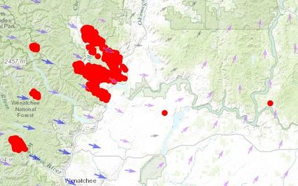
It's difficult to grasp the size of the fires burning in Washington when some says they've burned 168,000 acres. But most of us are familiar with our area on maps.
Here's a map of the area, with red dots representing the burn area and arrows giving wind direction.
The fires at Brewster and Pateros are more than 40 miles away. The smaller R Road fire near Leahy Junction is about 14 miles away as the ash flies.
That fire is just smoldering. The Carlton Complex is not contained and grew at possibly record pace before Pateros and part of Brewster had to be evacuated last night.
You can move the embedded map around to see different areas. And you can click the View Larger Map below it to see more detail or zoom out for a broader view.
Reader Comments(0)